AI Foundation Models and Artificial Intelligence in Forestry
────────────────────────────────────
FOREST AI
────────────────────────────────────
F11 AI Foundation Models and Artificial Intelligence in Forestry
When the Forest Grows a “Brain” and “Eyes” — Full-Scale Intelligence from Patrol to Management
Foreststellar · Xu Li
“Forest Assetization and Perpetual Forest Management” series · July 2026
Introduction: Why Talk About AI + Forestry
From F01 to F10 we have used ten chapters to travel from the financial-asset nature of forests all the way to the vision of Forest Coin and a global forest civilization system. But attentive readers may have noticed that throughout all of the earlier discussion one key piece of the puzzle kept flickering in and out of view without ever being explained on its own — the technological foundation.
Where does the “credibility” of forest assets come from? On what basis can the value of Forest Coin be “objectively verified”? What will carry forest management from extensive to precise? Who supervises the balance of “protection through development”? All of these questions ultimately point to the same answer: AI + artificial intelligence.
Without space-air-ground integrated remote sensing, why would you believe this patch of forest is really growing? Without real-time inference on edge AI, how would you make decisions deep in the mountains? Without robots and embodied intelligence, who will replace the 700,000 forest rangers who are growing old? Without foundation-model biodiversity projection, why should anyone trust a forecast of a forest asset’s future appreciation?
In this article we will take these foundational technologies apart one by one. I will try to use plain language so that readers without a technical background can follow — these technologies that look so “aloof” are in fact quietly changing the fate of every patch of forest in China.
1. Space-Air-Ground Integrated Remote Sensing: A Full-Body Checkup for the Forest
1.1 Why “Space-Air-Ground Integration”?
The difficulty of forest monitoring is that a forest is three-dimensional. The canopy layer is on top, the shrub layer in the middle, the ground-cover layer below, and the soil and root systems underground. Worse still, in a natural forest with high canopy density the crowns stack a dozen layers deep: looking down from the sky you see only the topmost “sea of trees,” and what happens beneath it is entirely unknown.
Under traditional manual patrol, a ranger walks 20 km of mountain trail in a day yet can see only a few dozen meters — the line of sight is blocked by trees, and gullies, steep slopes, and the depths of dense forest are blind spots. Satellites can see large areas but not fine detail; drones can fly in close but have limited endurance and are constrained by weather; ground sensors can monitor continuously but cover only a limited area. Only a three-layer combination of “satellite + aerial + ground” can deliver a “full-body checkup” for a forest.
1.2 Gaofen Satellites: From “Seeing” to “Seeing Clearly”
China’s Gaofen series of satellites (Gaofen-1 through Gaofen-14) now forms a complete Earth-observation constellation. Gaofen-6 in particular is dedicated to agricultural and forestry applications and carries a red-edge band — a band extremely sensitive to vegetation chlorophyll concentration, which allows a forest’s “greenness” to be judged for health from space.
Satellite data commonly used in forestry today has reached sub-meter spatial resolution (0.5–1 m) — meaning that from an orbital altitude of more than 600 km a satellite can capture the outline of a single tree’s crown clearly. Temporal resolution (revisit period) has also shrunk to 1–3 days. In other words, a satellite can pass over the same forest and photograph it once every 1–3 days. For scenarios where time is money — forest fire monitoring, illegal logging, pest and disease outbreaks — this frequency already has real operational value.
More important still is the use of multispectral and hyperspectral technology. Multispectral sensors capture data simultaneously in visible light (RGB), near-infrared (NIR), shortwave infrared (SWIR), and other bands. Healthy vegetation reflects strongly in the near-infrared (because the structure of mesophyll cells scatters NIR), whereas stressed vegetation shows a marked drop in NIR reflectance. By computing indices such as the Normalized Difference Vegetation Index (NDVI), AI algorithms can determine the growth and health condition of every single mu of forest land from space.
Hyperspectral goes further: rather than looking at a handful of bands, it slices the spectrum into several hundred contiguous narrow bands, forming an almost continuous “spectral curve.” Different tree species, different stages of pest and disease, and different degrees of water stress all leave a distinctive “fingerprint” on that curve. Just as a complete blood count can detect dozens of indicators in a person’s blood, hyperspectral imaging performs a “spectral blood count” on trees.
1.3 Seeing “Beneath the Canopy”: Multi-Spectrum Penetration Technology
Visible and near-infrared imagery from satellites and drones suffers from one innate defect: it cannot penetrate the canopy. In a natural forest with high canopy density the crowns stack more than ten meters deep, and visible light simply never reaches the ground. So how well are the understory shrubs growing? Is there soil erosion in the ground-cover layer? How thick is the litter of dead branches and leaves? This information is critical for assessing forest carbon sinks, fire risk, and biodiversity, yet from the sky it is simply invisible.
The key technologies that solve this problem are synthetic aperture radar (SAR) and light detection and ranging (LiDAR).
SAR satellites (such as China’s Gaofen-3 series) transmit microwaves — electromagnetic waves with wavelengths of a few centimeters to a few tens of centimeters. The great advantage of microwaves is that they penetrate: through cloud and fog, through the canopy, and even shallowly into the ground surface. By analyzing radar echo signals in different polarization modes (HH, HV, VH, VV), it is possible to invert key parameters such as canopy height, above-ground biomass, and understory topography. When a SAR satellite passes over, it can tell you not only how tall and how dense the forest is, but also whether the ground beneath the canopy is flat or gullied.
LiDAR, by contrast, actively emits laser pulses and measures the time difference between emission and return to calculate the three-dimensional coordinates of the target. Airborne LiDAR (mounted on an aircraft or a large drone) can scan a forest at a rate of several hundred thousand pulses per second, producing “point cloud” data accurate to the centimeter — from which you can read the height, crown width, and diameter at breast height of every tree (the last derived by algorithm), and even reconstruct a complete three-dimensional structural model of the forest.
Add ground-based LiDAR (set up on the forest floor to scan from below) and you can achieve all-round three-dimensional modeling from the sky to the understory to the ground. With this technology stack, a forest is no longer “a vague green impression” but a precisely quantifiable three-dimensional data volume — every tree an independent, trackable data point.
1.4 Below the Ground: Three-Dimensional Probing from Soil to Root System
A forest’s value is not only above ground. Underground root networks, soil organic carbon, microbial communities, groundwater distribution — these “invisible assets” are often the key to the health of a forest ecosystem and an important part of carbon sink accounting.
Ground-penetrating radar (GPR) on the ground can emit high-frequency electromagnetic waves that penetrate the soil layer to detect root distribution, soil stratification, and soil moisture content. Combined with multi-parameter soil sensors (which measure temperature and humidity, pH, organic matter content, electrical conductivity, and more at the same time), this makes it possible to build a “digital twin” of the forest’s underground portion.
One technology deserves particular attention: passive acoustic monitoring. By burying acoustic sensors in the soil and listening for the faint sound waves emitted as roots grow, it tracks root growth dynamics. The technology is still at the frontier research stage, but once mature it will mark a revolutionary leap from “digging to see the roots” to “listening to know the roots.”
1.5 The Next Twenty Years: From “Seeing Clearly” to “Understanding”

Figure 1 | Space-air-ground integrated remote sensing system: three-layer coordination of space-based satellites, airborne platforms, and ground-based sensors
Looking twenty years ahead, space-air-ground integrated monitoring will move in three directions:
First, constellation density will rise sharply. China’s civil remote sensing constellations are still in a phase of rapid build-out. Over the next twenty years the number of low-orbit satellites will grow from several hundred today to several thousand, the revisit period will shrink from days to hours, and near-real-time monitoring may even become possible. By then, any abnormal change in a forest — fire, logging, pests and disease — may take only a few dozen minutes to be detected from the moment it occurs.
Second, sensor fusion will become intelligent. Future monitoring satellites will no longer be “cameras” but “intelligent agents in orbit.” AI chips aboard the satellite will pre-process raw data in real time — automatically removing clouds, flagging anomalies, triggering change alerts — and only “valuable incremental information” will be downlinked to the ground. This will compress the latency from “the satellite sees it” to “the ground knows it” from hours to minutes.
Third, quantum sensing and gravity satellites will move toward civil use. Today gravity satellites (such as the GRACE series) measure minute changes in Earth’s gravity field to invert large-scale processes such as groundwater storage change and glacier melt. As quantum gravity sensors are miniaturized and their costs fall, this class of technology may move into forestry applications — “weighing” changes in a forest’s biomass from space. It sounds like science fiction, but it is already happening in laboratories.
2. Forest Patrol Robots: The Era of “Steel Forest Rangers” Opened by Solid-State Batteries
2.1 A Vanishing Cohort: The Predicament of 700,000 Forest Rangers
According to public figures, China now has roughly 700,000 forest rangers. That is a number both worthy of respect and cause for concern. Rangers hike more than 20 km a day, climbing steep slopes and pushing through dense forest, burning enormous physical energy. The work is dangerous — at one forest farm in Fujian, an average of two rangers are injured each year. Pay is low — about RMB 60,000 a year. The workplaces are deep mountains and old-growth forest, far from towns, and young people simply will not take the job.
More serious still, the existing corps of rangers is aging and retiring as a whole, with no successors. If no alternative is found within the next five to ten years, forest patrol in China will face a systemic labor shortfall. This is not a multiple-choice question of “whether to replace people with machines” but a mandatory question of “without machines there will be nobody left to do the job.”
2.2 Why Now? Solid-State Batteries Cross the Critical Point
The core bottleneck for a patrol robot is not the AI algorithm or the sensors; it is energy. For all-weather, all-terrain continuous operation deep in the mountains, battery energy density, safety, and wide-temperature performance are decisive.
The good news is that solid-state battery technology is breaking through the threshold of industrialization. Compared with conventional lithium batteries, solid-state cells promise 50%–100% higher energy density (reaching 400–500 Wh/kg), an operating temperature range widened to −40 °C to 80 °C, and a fundamental elimination of electrolyte leakage and thermal runaway risk — which is critical in a forest-fire-prevention setting. A patrol robot in dry woodland absolutely must not start a fire because of a battery failure.
China currently leads the world in the industrialization of solid-state batteries. CATL, BYD, WeLion New Energy, QingTao Energy, and others have already entered mass production of semi-solid-state batteries in 2025–2026, and all-solid-state batteries are expected to reach large-scale mass production in 2028–2030. This means that around 2030 patrol robots will have enough “stamina”: several hundred kilometers of range on a single charge, all-weather operation, and stable performance from the −30 °C forests of the northeast to the 40 °C tropical rainforests of the south.
2.3 All-Terrain, All-Weather, Self-Assembling: The Patrol Robot’s “Three Aces”
Based on our team’s in-depth study of patrol scenarios (see “Functional Requirements and Scenario Analysis for Forest Patrol Robots” in the Foreststellar folder on the desktop), an ideal patrol robot needs three core capabilities:
All-terrain: a wheel-track hybrid plus aerial coordination. The ground module uses an omnidirectional wheel-track hybrid chassis that balances speed (up to 1.5 m/s) with obstacle-crossing ability (35° climbing, 0.4 m obstacle height), handling mud, tree roots, loose rock, and other complex terrain. The aerial module integrates a launchable drone that takes off for high-altitude reconnaissance when dense forest blocks the view, and can fly over steep slopes or water. This “drive on the ground, fly in the sky” combination is the most realistic path under today’s technology.
All-weather: IP68 protection, a wide temperature range, and hybrid power. The complete unit is rated IP68 for dust and water resistance and operates from −20 °C to 60 °C. The main power source pairs a high-density solid-state battery with a solar back panel, supporting four hours of continuous work. Automatic tracking photovoltaic charging posts deployed in the forest area enable a long-endurance field mode of “recharging while on the move.”
Self-assembling: modular architecture with hot-swappable mission payloads. Patrol requirements vary enormously by season and by forest area — the fire season needs thermal imaging and gas sensing, the pest and disease season needs multispectral cameras and spore traps, and the anti-logging season needs voiceprint recognition and vibration sensing. The robot uses a modular architecture with hot-swappable mission payloads, so an operator can quickly “assemble” a patrol robot in a different configuration for the task at hand. Battery packs are modular too, and can be swapped hot in the field, avoiding long offline periods for recharging.
2.4 From “Machines Replacing People” to “Human-Machine Collaboration”
Gaofen series · SAR radar · multispectral / hyperspectral Fixed-wing UAV · multirotor · airborne LiDAR Forest patrol robots · soil sensors · infrared cameras · ground-penetrating radar
Space-based · satellite remote sensing
Air-based · aerial monitoring
Ground-based · ground sensing
Figure 2 | All-terrain forest patrol robot: solid-state battery powered, with a wheel-track hybrid chassis and aerial drone working in concert
A pragmatic judgment: within the next decade, patrol robots will not 100% replace human rangers. But they will fundamentally change the patrol model — from one ranger walking 20 km of mountain trail a day to one person managing 5–10 robots plus a drone plus a tablet terminal, with coverage rising more than tenfold and response time shrinking from days to minutes.
The “one machine, one dog, one tablet” pilot at the Wuchaoshan forest farm in Zhejiang has already proved the feasibility of this model, with efficiency gains of more than 30%. As solid-state batteries and AI algorithms advance, that multiple could reach 5–10 times within the next decade.
From an economic standpoint, an all-terrain patrol robot is expected to cost RMB 200,000–500,000 per unit (falling with production scale), with a service life of 5–8 years and annual operating and maintenance costs of about RMB 30,000–50,000. A 100,000-mu forest farm equipped with 20–30 robots, 5–8 drones, and a 3–5 person operations team would cost roughly RMB 1.5–2.5 million a year in total — compared with the 50–80 rangers the same area would otherwise require (annual labor cost of about RMB 4–5 million), a clear economic advantage.
3. Luxi Technology’s Brain-Inspired Foundation Model: Why Forestry AI Must Take “Another Road”
3.1 An Overlooked Core Question: Forest Data Cannot Go to the Cloud
Before discussing forestry AI, one prior question must be answered: can forest data be uploaded to a public cloud?
The answer is: for the most part, no. Forest resource data — compartment boundaries, species distribution, growing stock, locations of rare flora and fauna, water source areas, and so on — falls within the category of classified national geographic information. For border forest areas, important water-conservation forests, and defense forests in particular, the precision of coordinate information and the scope of its use are strictly controlled. Upload a 0.5-meter-resolution remote sensing image of a pristine border forest to an overseas cloud provider’s servers to run AI inference? That is not merely a compliance issue; it is a national security issue.
That is why forestry cannot directly use cloud-based foundation-model services such as ChatGPT, Claude, or Gemini — not because it is technically impossible, but because the regulations do not permit it. The AI forestry needs must be edge-deployed: the model runs on a local server, an edge computing node, or even an embedded chip, and the data never leaves the forest area.
3.2 Why a “Brain-Inspired Foundation Model” Rather Than a Transformer?
Today’s mainstream foundation-model architectures (the GPT, Claude, and Gemini families, among others) are built on the Transformer and matrix multiplication — their computational core is large-scale matrix arithmetic that depends on massive GPU clusters and extremely high power draw. This architecture is naturally suited to cloud deployment: cheap electricity, ample cooling, and computing power that scales without limit.
But in forestry scenarios the compute, power, and cooling available to edge devices are tightly constrained. An edge computing node mounted on a tower in a forest area may have a power budget of a few dozen watts, passive cooling, and a few hundred Kbps of network bandwidth — run a conventional foundation model requiring hundreds of GB of VRAM and several kilowatts of power under those conditions? Completely impossible.
The “brain-inspired foundation model” that Luxi Technology is developing takes a different route. Its core idea is to mimic how neurons in the human brain work: sparse activation, spike-driven, event-triggered. The human brain has about 86 billion neurons, yet while you read this paragraph only a tiny fraction are active; most are on low-power standby. The brain draws only about 20 watts, whereas a conventional AI model of comparable scale running on a GPU cluster needs tens of thousands of watts.
The key technical features of a brain-inspired foundation model include:
First, sparse computing. When a conventional Transformer model performs inference, every neuron in every layer takes part in the computation (dense computing); a brain-inspired architecture activates only the small number of neurons relevant to the current task, cutting computation by more than 90%. This means that for the same inference task, a brain-inspired chip draws one tenth the power of a conventional GPU chip, or less.
Second, spiking neural networks (SNNs). Conventional artificial neural networks process continuous values (floating-point numbers), whereas an SNN processes discrete “spikes” — a neuron fires only when it receives a sufficiently strong input signal. This mechanism is naturally suited to spatiotemporal data (sensor time series, video streams, acoustic signals) and matches perfectly with the “continuous sensor collection plus event-triggered alarms” pattern of forest monitoring.
Third, compute-in-memory. In conventional computing architectures data and computation are separate — data is moved from memory to the CPU/GPU and moved back after the computation. That shuttling accounts for about 90% of power consumption. Brain-inspired chips use a compute-in-memory architecture that computes directly where the data is stored, sharply reducing the power cost and latency of data movement.
To sum it up in one sentence: OpenAI’s architecture is designed for unlimited compute, cloud deployment, and general-purpose conversation; Luxi’s brain-inspired architecture is designed for constrained compute, edge deployment, and real-time inference. Forestry is exactly the archetypal case of the latter.
3.3 The Practical Value of Edge Deployment: Starting from a “Target Compartment”
Take a concrete example. Suppose you want an “AI decision consultation” for compartment No. 37 of a 100,000-mu forest farm: the main species is Chinese fir, stand age 15 years, the last thinning was three years ago, and recent remote sensing imagery shows NDVI declining in some areas. You want the AI to help you judge: does this stand need thinning? If so, what density should be maintained? And when is the optimal harvest timing?
Under a cloud foundation-model approach you would have to upload all the data for compartment No. 37 — remote sensing imagery, forest type maps, soil data, historical management records — to a cloud server, wait for the model to run inference, and then receive the result. Leaving aside classification and compliance, the “upload–wait–return” chain alone could take tens of minutes or even hours under weak-network conditions in the mountains.
Under an edge brain-inspired foundation-model approach, the data never leaves the forest area. An edge AI server installed in the forest farm’s equipment room (drawing under 200 watts) completes inference for compartment No. 37 in seconds to tens of seconds — producing thinning recommendations, growth forecasts, and risk warnings. And with continued use, the model keeps “self-learning” from the farm’s actual management data, understanding this particular forest better and better.
More important still is offline availability: even with no network at all (all too common in mountain areas), the edge model keeps working normally. For emergency scenarios where every second counts — forest fire prevention, intercepting illegal logging — it is irreplaceable.
3.4 Data Security and Compliance: The “Bottom Line” of Forestry Intelligence
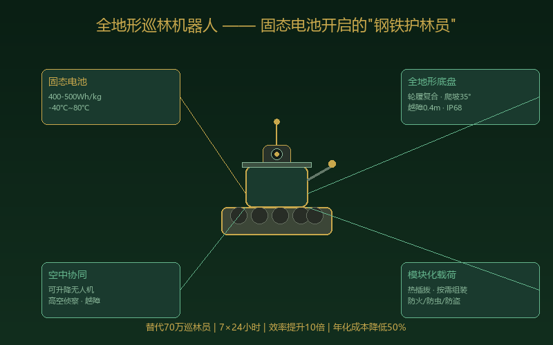
Figure 3 | Luxi Technology’s brain-inspired foundation model vs. a conventional Transformer architecture: sparse activation, edge deployment, offline availability
State regulation of geographic information data security is becoming stricter by the day. The Data Security Law, the Personal Information Protection Law, the Surveying and Mapping Law, and a series of departmental rules from the Ministry of Natural Resources all set explicit requirements for the collection, storage, processing, and transmission of classified geographic information. Forestry, as a sensitive field touching territorial space, natural resources, and ecological security, must use its data within a compliant framework.
The technical route of edge deployment plus a brain-inspired foundation model satisfies these compliance requirements at the architectural level — data never leaves the forest farm, never crosses a border, never enters a public cloud. This is not a “marketing point” but the “entry threshold” for whether forestry AI can scale. Without compliance, even the best technology cannot be deployed.
4. From Data to Insight: Dynamic Projection of Forest Biodiversity
4.1 Biodiversity: The Forest’s Most Valuable Yet Least “Explainable” Asset
In F09 and F10 we stressed one point repeatedly: the value of a forest asset goes far beyond timber. Biodiversity — species diversity, genetic diversity, ecosystem diversity — is the “base layer” of a forest’s long-term value. Thirty years on, the gap in ecological and economic value between a pure Chinese fir plantation and a mixed multi-species forest may be an order of magnitude.
The problem is that quantifying biodiversity is extremely difficult. The traditional method is to send a survey team to do quadrat sampling — run a few transect lines through the forest, place a quadrat at intervals, and count how many trees are inside, of what species, of what diameter and height. A 100,000-mu forest farm may have only a few dozen quadrat points — using a sample of one part in a thousand or even one part in ten thousand to infer the biodiversity of the entire forest. It is like sticking a straw into the ocean and claiming to know how many kinds of fish live in it.
4.2 All-Round Data Collection: Turning “Sampling” into a “Census”
The greatest value of a space-air-ground integrated monitoring system is that it moves forest inventory from “sampling” to “census.” Satellite remote sensing covers every mu of forest land, airborne LiDAR scans the form of every tree, ground sensors record environmental change at every moment, and environmental DNA (eDNA) technology identifies the animal and microbial species living in the forest by analyzing DNA fragments in soil and water.
When this data converges on a unified spatiotemporal data platform, we can build a “digital twin” of the forest ecosystem — a 1:1 replica in virtual space that updates in sync with the real world. In that model the location, species, height, diameter at breast height, and growth rate of every tree are known; the movement paths of every animal are traceable; and the carbon stock of every soil layer is computable.
4.3 Reasoning Foundation Models: Letting the Forest “Speak for Itself”
With the data in hand, the next step is reasoning and projection with an AI foundation model. This is where foundation models truly shine: they do not merely compile statistics (“how many species of tree are there now”) but perform causal inference and dynamic prediction (“if climate change raises average annual temperature by 2 °C over the next 30 years, how will the species composition of this forest change?”).
Specifically, an AI foundation model can project at several levels:
First, species distribution projection. Using known species occurrence points along with terrain, climate, and soil data, deep learning models predict where rare species not yet surveyed may occur — in essence “inferring the unknown from the known,” which can greatly improve the efficiency and coverage of biodiversity surveys.
Second, population dynamics projection. Using years of continuous monitoring data, AI can model the growth or decline trends of different tree species and predict changes in species composition 10, 30, and 50 years out. This matters enormously for forest management planning — if AI predicts that a species may decline 50 years from now because of climate change, you need to start considering substitute species for introduction now.
Third, carbon sink dynamics projection. Fusing multi-source data — growth models, climate projections, and remote sensing — AI can project the carbon stock curve of a given stand at different points in the future. That curve directly determines the expected future return on carbon sink trading, and it is one of the core bases for the Forest Coin valuation in F10.
Fourth, ecological network projection. AI can analyze interactions among species in a forest ecosystem (food webs, pollination networks, symbiotic relationships) and simulate the cascading effects across the whole ecosystem when a key species changes. These are conclusions that traditional ecology could only reach after decades of field observation; large-scale AI projection compresses that cycle to a few hours.
4.4 From Projection to Finance: Backing Credible Appreciation Forecasts for Forest Assets
Let us return to our core narrative — forest assetization and the Forest Coin system. We have always stressed that the value of Forest Coin is anchored to the real growth of forest assets. But how is “future growth” predicted? And why should anyone find the prediction credible?
The answer lies in the technology stack described in this chapter. When a forest’s growth condition is continuously collected by space-air-ground integrated sensors, when an AI foundation model builds multi-scenario projections on that data, and when those projections are attested on-chain through an oracle — the future appreciation of a forest asset turns from a “subjective judgment” into a “verifiable objective forecast.” It is like a weather forecast: not 100% accurate, but because its methodology is transparent, its historical backtests are verifiable, and it is updated frequently, society at large is willing to trust and use it.
An institutional investor in Forest Coin does not need to travel to the forest and count trees in person. He need only review the monitoring data reports on-chain and the AI projection conclusions to judge whether “this forest’s 30-year carbon sink growth curve is reliable.” This is the “trust infrastructure” that AI builds for the forest financial system.
5. Embodied Intelligence and Industrial Robots: A “Steel Legion” for Every Forestry Scenario
5.1 Forestry Robots: A Vastly Underestimated Hundred-Billion Market
When people talk about robots, they first think of robotic arms in factories, AGVs in warehouses, robot vacuum cleaners at home. Few think of the forest — an industry considered “primitive,” “extensive,” and “at the mercy of the weather.” Yet precisely because it is “primitive,” forestry holds the largest room for robot substitution.
According to industry estimates, the global forestry robot market was about USD 3 billion in 2025 and is expected to grow to more than USD 30 billion by 2035, a compound annual growth rate above 25%. China’s share is expected to rise from about 15% today to more than 30% — because China has the world’s largest planted forest area, its most complete manufacturing supply chain, and the most urgent need for labor substitution.
This market can be broken down into the following core tracks:
5.2 Harvesting Robots: From “People Climbing Trees” to “Machines Picking”
Forest harvesting — resin tapping, fruit picking (oil-tea camellia fruit, walnut, chestnut, pine nuts), and bark collection (medicinal materials such as eucommia and magnolia bark) — is the most labor-intensive and most dangerous part of forestry today. Traditional resin tapping requires workers to climb hundreds of pine trees a day to score the bark and fit cups; oil-tea camellia fruit must be picked tree by tree with large crews. The physical toll is enormous and safety accidents are frequent.
The technical path for harvesting robots is maturing quickly: computer vision plus multi-degree-of-freedom robotic arms plus compliant force control can identify ripe fruit precisely and pick it gently. Different species’ harvesting needs have produced several configurations — climbing (ascending the trunk to pick), suspended (operating in the air along a cableway), and vehicle-mounted lift (vehicle plus lifting platform plus robotic arm).
Take oil-tea camellia fruit as an example: a camellia harvesting robot currently costs about RMB 300,000–500,000 per unit and picks 3–5 mu a day (roughly the equivalent of 5–8 workers). With a 60-day picking season each year, the equipment investment pays back in about two years. As production scale grows and vision algorithms mature, picking efficiency is expected to reach 8–10 mu a day within five years.
5.3 Planting and Tending Robots: Turning “Afforestation” into “Intelligent Manufacturing”
Planting — site preparation, hole digging, seedling placement, soil covering, watering — is the hardest physical labor in forestry. In the hilly country of the south, a worker who plants 100–200 seedlings in a day is already exhausted. Today, fully automatic planting robots have entered pilot trials at some forest farms.
These robots generally use a tracked chassis carrying high-precision GPS/BeiDou positioning (±2 cm) together with a terrain-sensing system, and can automatically complete the full sequence of hole digging, seedling placement, soil covering, and watering at a preset optimal planting density and layout. One machine can plant 1,000–2,000 seedlings a day, more than ten times the efficiency of manual labor.
On the tending side, intelligent brush-cutting robots use visual recognition to distinguish “target species” from “competing weeds and shrubs,” clearing only the non-target vegetation that competes with the target species and greatly reducing herbicide use — a significant gain for FSC certification and organic forest product certification. Intelligent fertilizer robots use real-time data from soil sensors to deliver precise per-tree fertilization — “one tree, one prescription,” measured to the gram.
5.4 Understory Economy Robots: Automation from “Mushrooms” to “Honey”
The understory economy is an important part of forestry’s comprehensive returns — understory cultivation (edible fungi, medicinal herbs, wild vegetables), understory breeding (bees, free-range chickens, black pigs), and understory gathering (wild mushrooms, honey, medicinal materials). Demand for robots in these scenarios is growing fast:
Understory edible-fungus harvesting robots — which use vision to judge ripeness and compliant robotic hands to pick without damage — have already entered commercial use for shiitake, wood ear, and other varieties.
Smart beehives — fitted with multidimensional sensors for temperature and humidity, weight, sound, and bee traffic — let AI algorithms judge colony health, honey ripeness, and even the state of the queen from changes in the frequency of the colony’s flight sound. One smart hive can replace more than 50% of the traditional beekeeper’s hive-inspection workload.
Intelligent harvesting of understory medicinal materials — soil sensors plus multispectral drone scanning can pinpoint the distribution and growth state of wild or semi-wild medicinal plants in the understory and guide precise harvesting: take the mature, leave the small, achieving sustainable management of understory resources.
5.5 Forest Tourism (Wellness) Robots: From “Guide” to “Guardian”
Forest tourism and wellness are the core growth pole of forestry’s tertiary sector. With China’s population aging and explosive growth in urban middle-class demand for “natural healing,” the forest wellness market is expected to reach the trillion-yuan level by 2030.
In this scenario, embodied-intelligence robots can play multiple roles:
Companion guide. A forest guide robot carrying a large language model can identify the plants and animals in the forest and explain them to visitors — “that tree ahead on your left is a Chinese yew, a national first-class protected plant, about 80 years old; its paclitaxel extract is used in anticancer drugs…” This “walking encyclopedia” experience is something neither a traditional human guide nor a mobile app can provide.
Safety and rescue. The safety risks of forest tourism cannot be ignored — getting lost, falls, wild animals, sudden illness. A rescue robot carrying life-detection radar, thermal imaging, and satellite communication modules can, after receiving a distress signal, navigate autonomously to the person in trouble, deliver emergency medical supplies, act as a communications relay, provide warming equipment, and even carry an adult out of the danger zone.
Health monitoring. The “therapeutic effect” of forest wellness has long been criticized for lacking quantified evidence. Wearable sensors plus an AI health-analysis robot solve the problem outright: they monitor physiological indicators in real time — heart rate variability (HRV), blood pressure, blood oxygen, cortisol level (via saliva testing) — and use data to prove that “after three days in the forest your stress hormone level fell by X% and your immune function indicators rose by Y%.” This quantified health data will become a core basis for pricing forest wellness products.
5.6 Market Size Overview
| Segment | 2025 (RMB 100 mn) | 2030 (RMB 100 mn) | 2035 (RMB 100 mn) |
| Patrol and monitoring robots | 5 | 80 | 250 |
| Harvesting / planting / tending robots | 8 | 120 | 380 |
| Intelligent understory-economy equipment | 3 | 50 | 150 |
| Forest tourism / wellness robots | 1 | 40 | 200 |
| Space-air-ground monitoring hardware and services | 15 | 150 | 400 |
| Forestry AI software and platforms | 5 | 100 | 350 |
| Total | 37 | 540 | 1,730 |
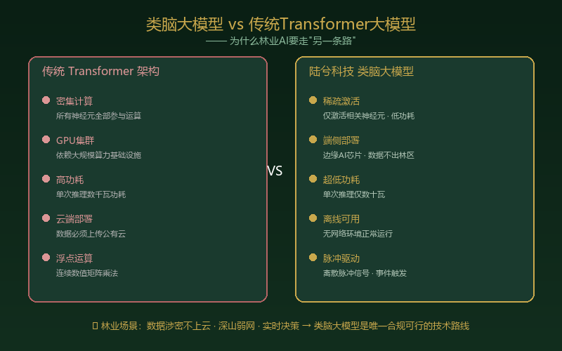
Figure 4 | The full-scenario map of forestry robot applications: six core tracks and market-size projections
Drawing these tracks together, our team has made a preliminary estimate of the forestry robot and embodied intelligence market:
This estimate may lean conservative. Considering the enormous base of roughly 60 billion mu of forest worldwide, and China’s industrial position as the world’s largest forest-products nation (first in both timber imports and plywood exports), forestry AI and robotics could well become a trillion-yuan industrial cluster by 2035.
6. A “List Revolution” in Hardware: How Much Smart Equipment Does a 100,000-Mu Forest Need?
6.1 The Conclusion First: 100,000 Mu ≈ RMB 150–200 Million in Smart-Equipment Investment
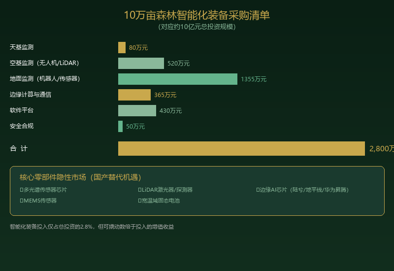
To give readers an intuitive feel for the granularity of this market, let us take a standardized 100,000-mu mixed forest in the south (corresponding to a total investment of about RMB 1 billion) and break down its smart-equipment procurement list. The figures below are based on current market reference prices and industry research estimates:
In other words, for a 100,000-mu forest farm the total investment in smart equipment and software systems comes to about RMB 28 million — roughly 2.8% of the project’s total investment. The proportion looks modest, but the gains in efficiency and management precision are enough to leverage appreciation several times the outlay.
6.2 The “Hidden Champion” Opportunity in Key Components and Sensors
| Category | Specific equipment | Quantity | Unit price (RMB 10,000) | Subtotal (RMB 10,000) |
| Space-based monitoring | Commercial satellite data, annual subscription | - | 80/year | 80 |
| Airborne monitoring | Fixed-wing inspection drone (3 h endurance) | 8 | 30 | 240 |
| Airborne monitoring | Multirotor reconnaissance drone | 20 | 5 | 100 |
| Airborne monitoring | Airborne LiDAR pod | 3 | 60 | 180 |
| Ground monitoring | All-terrain forest patrol robot | 25 | 35 | 875 |
| Ground monitoring | Automatic weather / soil monitoring station | 60 | 3 | 180 |
| Ground monitoring | Wildlife infrared camera + AI recognition unit | 200 | 0.5 | 100 |
| Ground monitoring | Early forest fire detection sensor | 80 | 1.5 | 120 |
| Ground monitoring | Automatic hydrological / water quality monitoring station | 10 | 8 | 80 |
| Edge computing | Edge AI server (with brain-inspired AI chip) | 5 | 25 | 125 |
| Edge computing | Forest-area communications tower + LoRa/5G base station | 8 | 15 | 120 |
| Edge computing | Solar + energy storage power system | 40 | 3 | 120 |
| Software platform | Forest digital twin platform | 1 | 200 | 200 |
| Software platform | Forestry AI inference software (with model licensing) | 1 | 150 | 150 |
| Software platform | Mobile app + management dashboard | 1 | 80 | 80 |
| Security and compliance | Data encryption and compliance audit system | 1 | 50 | 50 |
| Total | - | - | - | 2,800 |
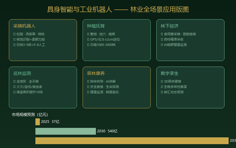
Figure 5 | Smart-equipment procurement list for a 100,000-mu forest: RMB 28 million in investment leveraging several times that in appreciation gains
Behind this procurement list lies a more noteworthy “invisible market”: core components and sensors. Every piece of smart equipment above depends on the following key components:
-
Multispectral/hyperspectral sensor chips: high-end products today are mainly imported (Headwall, Specim, Resonon, for example), while domestic substitution is accelerating (the Changchun Institute of Optics, Fine Mechanics and Physics under the Chinese Academy of Sciences, Beijing Zolix, and others) — one of the most certain local-substitution tracks of the next decade.
-
Core LiDAR components: lasers, detectors, MEMS scanning mirrors, scanning modules — Chinese companies such as RoboSense and Hesai Technology are already global leaders in automotive LiDAR, and transferring that technology to forestry LiDAR is only a matter of time.
-
Edge AI chips: domestic AI chip makers such as Luxi Technology, Horizon Robotics, Cambricon, and Huawei Ascend already have the capability to replace NVIDIA’s Jetson series in edge inference. Forestry’s requirement of “low power + real time + data never leaving the domain” is precisely the natural battleground where domestic edge AI chips hold the advantage.
-
MEMS sensors: accelerometers, gyroscopes, barometers, temperature and humidity sensors, gas sensors — the core components of robot attitude control and environmental perception. International giants such as Bosch and STMicroelectronics currently dominate, but domestic players like MEMSensing and Goertek Microelectronics are catching up fast.
-
Wide-temperature cells and solid-state batteries: the “heart” of a forestry robot. As noted earlier, solid-state batteries are crossing the industrialization inflection point, and this is a track of absolute advantage for Chinese manufacturing — the capacity and cost advantages of CATL and BYD should resolve forestry robots’ “range anxiety” entirely within the next five years.
7. Giving Forestry Companies Their Own “Sky Eye”: The Compliant Path to Civil Satellite Data
7.1 A Favorable Policy Climate: Civil Satellite Data Is Gradually Opening Up
In the past, high-resolution satellite remote sensing data was a strictly controlled strategic resource. Commercial purchase of satellite imagery at 0.5-meter resolution or finer required approval at every level, and its use was tightly restricted. But with the rapid growth of China’s commercial space industry and the demands of international competition, civil satellite data policy is undergoing a historic “loosening.”
In 2015 the National Medium- and Long-Term Plan for Civil Space Infrastructure set out the position of commercial remote sensing satellites for the first time. Since 2020, Chinese commercial remote sensing satellite companies — Chang Guang Satellite Technology (the “Jilin-1” constellation), PIESAT (the “Nuwa” constellation), Twenty First Century Aerospace Technology (“Beijing-2/3”), MinoSpace, and others — have risen rapidly, pushing resolution from the meter to the sub-meter level and growing constellation size from a few satellites to more than a hundred.
More important still, policy is shifting from “restricting use” to “standardizing use plus promoting applications.” Competent authorities such as the Ministry of Natural Resources and the China National Space Administration have issued policy documents encouraging the open sharing of commercial remote sensing data and promoting the satellite application industry. For forestry companies, lawfully obtaining and owning satellite monitoring data for their own forest areas is turning from “impossible” into “doable.”
7.2 The Compliant Path: How Forestry Companies Can Own “Their Own Satellite Data”
At present there are mainly three paths by which forestry companies obtain satellite data:
Path one: purchase commercial satellite data services (fastest). Sign an annual data service agreement with a commercial remote sensing company such as Chang Guang Satellite or PIESAT. For a 100,000-mu forest area, quarterly 0.5-meter optical imagery plus monthly 3-meter multispectral imagery plus SAR imagery on demand runs about RMB 800,000–1.5 million a year. This is the most mature and most compliant approach today: the data provider handles classified-information compliance, and the company simply uses the data.
Path two: deploy your own drones and ground remote sensing systems (most flexible). For priority forest areas a company can build its own “airborne remote sensing network” — fixed-wing drones, multirotor drones, and ground IoT sensors. This enables on-demand, high-frequency monitoring of priority areas, with the data entirely your own and no constraint from satellite revisit periods. The drawback is the need to build a professional drone operations team.
Path three: jointly order dedicated remote sensing satellite data (most cutting-edge). This is a new model that appeared after 2025: several forestry companies or an industry association jointly order a “virtual dedicated satellite” service from a commercial satellite operator. Across the multiple satellites it operates, the operator reserves specific overpass windows and areas for the client and images the client’s forest areas at an agreed frequency (once a day or once every three days, for example). The client holds exclusive use rights to that data. The cost of this model sits between path one and building your own satellite — about RMB 2–5 million a year — but for a large forestry group the value is outstanding.
7.3 Renting Satellites vs. Building a Constellation: Cost and Future Considerations
People often ask: should a forestry company “rent satellites” or “build satellites”?
At the current stage the answer is very clear: rent, do not build. A commercial remote sensing satellite currently costs RMB 50–200 million to manufacture and launch (depending on resolution and payload complexity), with an orbital life of about 5–8 years. To cover a specific area once a day you need a formation of at least 3–5 satellites — a total investment of roughly RMB 200 million to 1 billion. That does not yet count ground tracking and control stations, data receiving stations, or the operations team.
For any forestry company that outlay is simply too large. The more sensible approach is the “data as a service” model: pay by the year for satellite data.
But looking 10–20 years ahead, as super-heavy launch vehicles such as SpaceX’s Starship drive unit launch costs down to a tenth of today’s level or lower, and as satellite miniaturization and batch production advance, the “cost to orbit” of a remote sensing satellite may fall from tens of millions of yuan today to a few million. At that stage, a large forestry group holding several million to tens of millions of mu of forest could economically justify building its own “forestry-dedicated remote sensing small constellation” (3–5 small SAR/multispectral satellites, total investment RMB 100–300 million).
More important still is “data sovereignty”: in the future forest financial system, whoever owns the source of forest monitoring data holds the initiative in defining value. A proprietary, trustworthy data source is one of the core competencies for issuing Forest Coin, participating in carbon sink trading, and tokenizing forest assets as RWA.
7.4 A Pragmatic Roadmap
For most forestry companies we recommend a three-step sequence:
Step one (2026–2028): sign up for commercial remote sensing data services. An annual fee in the RMB 1 million range quickly establishes “space-based monitoring” capability. Build your own drone and ground sensor network in parallel.
Step two (2028–2032): upgrade to a “virtual dedicated satellite” service. An annual fee in the RMB 2–5 million range buys higher-frequency, higher-quality dedicated data. Deploy an edge AI inference platform in parallel to build a closed loop of “data collection–real-time analysis–intelligent decision-making.”
Step three (2032–2035+): evaluate building your own small constellation. When launch costs have fallen far enough and the forest area a company manages reaches the several-million-mu level, consider joining with an industry association or industry alliance to invest in a “forestry-dedicated remote sensing satellite constellation.” This is not only a data source but the “infrastructure” of a company’s voice in the global forestry value chain.
Conclusion: What AI Plants Is Not Code, but the Forest of the Future
Writing this, I think back to a scene ten years ago, visiting forest farmers deep in the mountains of Fujian. An old farmer pointed at the Chinese fir forest on the hillside and said to me: “Young Xu, I’ve been growing this stand for more than twenty years. I come to look at it every day, but honestly I don’t really know how much it grew each year — I only know roughly, approximately, more or less.”
Forestry ten years ago ran on experience. Forestry ten years from now should run on data. Ten years beyond that, forestry should run on AI.
In the sky, hundreds of satellites scan your forest area every few hours, and every tree’s growth condition is precisely recorded. In the mountains, patrol robots move tirelessly through the forest, guarding against fire, pests, and theft — seeing farther and reacting faster than any person. At the edge of the compartment, an edge AI server hums quietly on a few hundred watts, understanding this forest better than any forestry engineer — when to thin, where to replant, how great next year’s pest and disease risk will be; it can give a more accurate judgment than a human.
More important still, all of this will be written into trustworthy records on the blockchain. An investor in any corner of the world need not come to a remote Chinese mountain to look at the forest; by reviewing on-chain data — remote sensing monitoring reports, AI growth projections, carbon sink increment curves — they can make an investment decision. The forest turns from a physical asset that is “visible but untouchable” into a digital asset whose “data is trustworthy and value is transparent.”
This is the ultimate vision of AI + forestry: let the value of every tree be seen, let the growth of every patch of forest be trusted, and let the forest truly become the underlying asset anchor of human civilization.
What AI plants is not code. What AI plants is the forest of the future.
(Next: F12 The Global Carbon Sink Market Game — Opportunities and Challenges for Chinese Forestry)
— Foreststellar · Forest Assetization and Perpetual Forest Management Series —
────────────────────────────────────